Alliance Members

Back Bay Watershed Association
Eel River Watershed Association
Herring Ponds Watershed Association
Jones River Watershed Association
Neponset River Watershed Association
North and South Rivers Watershed Association
Pembroke Watershed Association
Save the Bay: Narragansett Bay
Six Ponds Improvement Association
Taunton River Watershed Association
Weir River Watershed Association
Westport River Watershed Alliance

Showing posts with label dorie stolley. Show all posts

Monday, September 23, 2013

Celebrating Wildlife


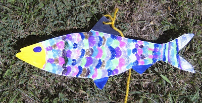
River herring decorated with glitter glue
Iridescent river herring created by Julia at the Cape Cod Wildlife Festival
Photo by Dorie Stolley 

What’s always fun for kids? Glitter glue! And, we had lots of it at the recent Cape Cod Wildlife Festival held at Mass Audubon’s Long Pasture Wildlife Sanctuary in Barnstable, MA. Kids listened to the story of mighty river herring battling their ways upstream, the obstacles they face and how people can help, as they decorated their own fish to take home. Creativity abounded, as did paint, glue and markers.

Big thanks go to Julia and Olivia, two girls who adopted our booth and assisted for hours, cutting out fish, encouraging children, keeping the tables clean and creating their own lovely herring.
Another river herring to join the school
Julia and her second herring
Photo by Heather Fone

Decorate-a-river-herring craft table
Olivia hard at work during a rare quiet moment at the booth
Photo by Heather Fone
 
Those who chose to keep their herring had a colorful souvenir of the day. The WAA website address was included on every fish so parents could visit it to learn about their local watershed, find simple ways to conserve water and locate fun water-related events all over southeastern Massachusetts.

Some children left their herrings for WAA. These fish will join the ever-increasing river herring school that will “march” in the July 4th parade in Plymouth with the Plymouth Nature Brigade.
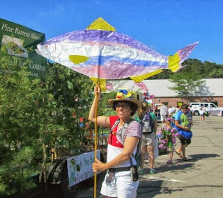
Colorful fish in July 4th parade
In 2014, there will be an entire school of herring to join the WAA mascot!
Photo by Lianna Lee

Banner on car in July 4th parade
Banner for the Plymouth Nature Brigade
Photo by Lianna Lee

 
kids dress in costume for the July 4th parade
Monarch butterfly, blueberry bush, and ladybug joined the river 
herring in representing Plymouth's native wild animals and plants
in the July 4th parade. Join us in 2014?
Photo by Lianna Lee
The arts are used in many ways to stimulate environmental stewardship, conservation and activism. WAA’s decorate-a-herring activity promotes emotional connection to and aesthetic appreciation of native water-dependent wildlife and conveys information in a natural, storytelling fashion to children and their parents. It also promotes regional pride in an impressive fish with an evocative story whose future depends on the work of WAA, its member organizations and people who care about them and about clean water. For more information visit: www.watershedaction.org

Friday, September 20, 2013

Did You Know? How to Keep Your Watershed Healthy in Autumn

Autumn colors along the Taunton River by Bharani Padmanabhan, MD, PhD 
There is nothing like the glorious New England fall foliage reflected in the crystal clear waters of our ponds and streams. Let’s make sure we keep our water clean and plentiful this autumn. Here are some easy ways for you to help your watershed during this time of year. Reduce the amount of water you put on your lawn and garden. Stop fertilizing your lawn until the spring (or forever). Pump out your septic tank. Clean up your pet’s waste. Join your local watershed association (Find yours at: www.watershedaction.org).

These easy actions help combat three common autumn issues in watersheds--low stream flow, eutrophication and bacterial contamination--and help to keep our waters beautiful and unpolluted.

Low stream flow means there is too little water in a stream, which might go completely dry, stranding fish in ever diminishing pools of water. This is not a pretty sight nor healthy.

More frequently, water is still visible in a stream, however, levels drop so low that fish and other wildlife have trouble traveling and completing critical stages in their life cycles. For instance, due to little rain and use of water in the summer, streams can drop too low for young river herring, hatched upstream in the summer, to migrate downstream to the ocean where they will grow to adulthood.
Everyone can help by conserving water in the summer and early fall, such as by using sprinkler systems in the early morning or evening rather than during midday when the heat will cause much of the water to evaporate.

In fact, this is such a simple, feasible and successful idea that the towns of Hingham, Hull and Cohasset, served by Aquarion Water Company, implemented mandatory water restrictions in early July to protect their water supply before it became critically low. Residents could only use sprinklers or irrigation systems every other day and only before 10 a.m. or after 6 p.m. North and South Rivers Watershed Association estimated that this simple procedure saved 30,000 gallons of water per day. This assured that residents would have water all summer long and that streams wouldn’t run dry. A double winner.

Eutrophication is another issue at this time of year. It happens when a water body receives too many nutrients, which causes explosive plant growth. When the plants die they sink to the bottom of the water body where bacteria feed on them. This process uses up the oxygen that is dissolved in the water, which can lead to fish kills. The excess nutrients are often a result of human activities. For example, fertilizer from farm fields or lawns, sewage from faulty septic systems or leaky sewer pipes and pet waste can all contribute to nutrient overloading in water bodies.

Fortunately, there are some easy ways for everyone to help solve this problem. These include: decreasing fertilizer on lawns (or not using any), getting septic tanks inspected and pumped on a regular schedule (every three to five years is recommended), and picking up pet waste.

The third watershed issue in the late summer and early autumn is bacterial contamination. Many beaches are closed to swimming in the summer because of high bacteria counts, which can continue into the fall, often not noticed because monitoring stops, beaches close for the season and fewer people are swimming. Bacteria in the water can cause many undesirable problems including eye, ear and stomach infections.

There are two important ways to help solve this problem: getting your septic tank pumped out on a regular schedule and picking up pet waste. Sound familiar? These actions both reduce bacterial contamination and nutrient overloading.

For more ways to help your watershed all year long, visit: http://watershedaction.org/index.php/take-action/at-home.

Monday, July 29, 2013

"Did You Know?" Community Building through Watershed Recreation

“Did You Know?”
Community-Building through Watershed Recreation
By Shalen Lowell

Everybody needs beauty as well as bread, places to play in and pray in, where nature may heal and cheer and give strength to body and soul.”

So wrote John Muir in his 1912 book, The Yosemite. Muir spoke of the restorative quality of our natural environments, and as such recognizes them as integral parts of our lives. Much as we can benefit from nature in its spiritual as well as material resources, we must recognize what we can do to repay the environments in which we live.

Dorie Stolley, "Great River Race Preparation"
As many of the southeastern Massachusetts watershed associations realize, one of the best ways to get people, whether adults, children, concerned citizens, or budding environmental activists, involved in their communities is through recreational activities. Many of these associations bolster this sense of community with volunteer opportunities. Some volunteering does not require a big commitment but, nonetheless, gets people out for a fun and active day as a means of contribution.

Participating in river herring counts encourages people to take action and learn about the environment of their community, in a small and simple way. Herring counts determine how many herring are returning to a system or how many are blocked by a specific dam, and citizen involvement is a perfect and manageable way to help. Two organizations, the North and South Rivers Watershed Association  (NSRWA) and the Jones River Watershed Association (JRWA) accept volunteers in the spring to assist with herring counts, and for the JRWA this occurs at the Elm Street dam in Kingston, Massachusetts.

The JRWA also sponsors other enjoyable activities such as a summer hiking series, family-friendly hikes from Jones River headwaters to Kingston Bay. Other recreation in the Jones River watershed includes boating from Kingston Bay out to Cape Cod Bay, and canoeing and kayaking from Mulliken's Landing, a put-in on the Jones River.

Shalen Lowell, "Neponset River Reservation"
The Neponset River Watershed Association (NepRWA) also recruits volunteers to bolster community-building efforts with their Citizen Water Monitoring Network (CWMN), for which volunteers help with water sampling in Neponset waterways. Public parks in the Neponset watershed provide great recreation opportunities. Where the Neponset empties into Dorchester Bay sits Squantum Point Park, a former Navy airfield. The Lower Neponset River Trail, a multi-purpose trail and “corridor park” that runs along the Neponset River and alongside old railroad tracks, is ideal for cycling, running and walking because of its seclusion from traffic and resting spots that include information about local wildlife and maps. The Neponset watershed also has a boat launch at the Neponset estuary.

The recreational activities of the North and South Rivers watershed are similar to Neponset’s. Kayaking, canoeing, and motor boating abound in the North River. Residents along the river build decks to which they dock their boats and from which they fish or jump into the river to enjoy its cool waters by swimming. The NSRWA also sponsors many other fun activities, such as water quality monitoring by volunteers (like the NepRWA), the Great River Race, Yoga at the River’s Edge, and River Cleanup Days.

Much like the North River, Great Herring Pond, of the Herring Ponds watershed, is a hotspot for water recreation. Residents in Plymouth and Bourne partake in swimming, kayaking, fishing, sailing, and even jet skiing. There is a Great Herring Pond public access boat launch in Bourne from which people depart into the pond. Little Herring Pond has a public access point as well for canoeing and kayaking, however motor boating is forbidden because of its shallow waters.

Shalen Lowell, "The NSRWA Great River Race"
The Little and Great Herring Ponds are two of the activity hubs in this watershed, over which the Herring Ponds Watershed Association (HPWA) watches. In this watershed, there are many parks and day camps as well: Camp Clark, just ashore of Hyles Pond, is a YMCA day camp for children and has nature trails and swimming; Hedges Pond Recreational Area is a Plymouth town park open to the public on afternoons and weekends. There is a Massachusetts Maritime Academy facility on Great Herring Pond that offers sailing lessons and rowing. The Carter Beal Reservation Area just to the south has a lovely park and trails. Finally, the Herring Run Recreation Area along Cape Cod Canal fronts a paved pedestrian trail, which is closed to traffic and used for biking, jogging, and walking and the Canal abounds with boats.

Just as outdoor recreation is important for our spirits and health, it is equally as vital to community-building and connecting networks of dedicated citizens. These ponds, rivers, and parks not only bring us together, but teach us to appreciate the inherent value of our environments and a desire to preserve them.

If you would like to volunteer and be active in your community contact your local watershed association today. To learn more about the southeastern Massachusetts watersheds and how to contact your local watershed association visit the Watershed Action Alliance website and http://watershedaction.org/index.php/watershed-matters/know-your-watershed

Wednesday, July 3, 2013

Kayaking on the North River!

Today’s Blogger is Shalen Lowell!

I’m always diving into new things, so last week I went kayaking for the first time! As part of the 2013 Wampanoag Paddle Fundraiser, Dorie and I paddled the 12.5 mile first leg of the Wampanoag canoe passage to experience first-hand the North and South Rivers watershed.

This watershed comprises 12 towns including Norwell, Scituate, Hingham, Hanover, Pembroke, and Weymouth, is an expansive watershed, and was known for shipbuilding. Used as channels for melt water when the glacier moved north around 10,000 years ago, the North and South Rivers surround 3,000 acres of salt marsh and 2,000 acres of endangered species habitat. The North River rises the from marshes and springs in Weymouth, Rockland and Hanson, emptying into the Atlantic, and the South River’s source is Round Pond in Duxbury.

The watershed’s topography is dynamic: for instance, as the rivers deposited silt, the salt marshes extended, keeping up with the sea level rise. The watershed lowlands contain fresh and salt water marshes, crucial for stormwater runoff and habitats for local wildlife, whereas a small section for the uplands is used for agriculture.

The NSRWA is working on Third Herring Brook, a tributary of the North River. As of now, herring can only access the bottom part of the watershed system, and have trouble moving upstream. There is only a 26% passage outflow in the fall. The Third Herring Brook has four dams that traverse its main stem. The NSRWA is working to take out one dam, funded by the YMCA, which is hesitant to go through with the dam destruction because of a lack of funds.


Peter Kelly-Detwiler and Nik Tyack once again paddled the 72-mile long passage mentioned above to raise money for the North and South Rivers Watershed Association. In a statement about their fundraiser, Peter and Nik said, “We hope to both raise awareness of Massachusetts' beautiful rivers and also support the North and South Rivers Watershed Association in their pioneering efforts to preserve and restore the watershed we grew up in. Recent successes of the organization include bringing river herring back to Scituate's First Herring Brook and re-opening shellfish beds on the South River.”

We kayaked down Herring River from the Driftway Park in Scituate, to where the Herring meets the North in proximity to the ocean. We then entered up the North River. I traveled with Dorie half the time, and the other half by myself; as a writer some reflection time suits me well.  Upon reflection, the journey seems a blur of riverside docks and waterfront properties, sprawling forests, and tall grasses. I do, however, remember feeling exhilaration as I swept down the river and jetted right under a highway overpass. Nothing pumps me up like the adrenaline of emerging under a bridge and into the open for a new adventure. I tired quickly by the end of my journey and my arms ached the entire day after! The repercussions were well-worth the experience though.

This journey was a unique one. So far, I’ve been viewing the southeastern MA watersheds and their main waterways from their shores, looking at the rivers. But instead of touring the watershed land, we were actually on the water, where I was able to gain a different perspective. We literally traversed the land as if we, too, were the North River.

This perspective led to an overwhelming contemplation about the North River: I thought about just this one river, and the countless ecosystems it encompasses, which broadened to the North and South Rivers watershed, to the millions of waterways in this country and in the world, the minute and fragile, interlocking environments. Each environment is its own, and also connects to all others; each one is vital to its environment and to the lives of organisms around the world. I also imagined what it was like for the Wampanoag Native Americans to have to traverse the waters, how taxing, frustrating, and rewarding it must have been.

Thanks to this experience, I’ve found that kayaking is something I could see myself doing long-term. A big shout out to the NSRWA for sponsoring this fun and successful event and for their ongoing work on ecosystem restoration in the watershed! If you want to learn more about the North and South Rivers watershed or NSRWA’s advocacy, history, and volunteer opportunities, visit http://www.nsrwa.org/ or log onto http://watershedaction.org/.

Tuesday, June 25, 2013

Did You Know? Closed-Cycle Cooling and the Pilgrim Power Plant

“Did You Know?” Closed-Cycle Cooling and Pilgrim Power Plant
By Shalen Lowell
Photo from: Greg Derr/The Patriot Ledger,
“Pilgrim Nuclear Power Plant”
http://www.patriotledger.com/news
/x1671800479/
Pilgrim-nuclear-plant-now-
in-6th-day-offline#
axzz2X9jmbeGW

Did you know that every day the Pilgrim Nuclear Power Station in Plymouth, Massachusetts absorbs 510 million gallons of water from Cape Cod Bay? In operation since 1972 and owned by Entergy, the Pilgrim Station poses a continual threat to the surrounding ecosystem and residences, due to its outdated, once-through cooling system. Last May, Pilgrim renewed its 20-year operating license, and this action further motivated activists to unceasingly protest its ongoing harm to the ecological community.

Pilgrim runs on a once-through cooling system, in which it sucks in water  from the Bay. That water absorbs heat from the plant operations and is then discharged. This “once-though” water can be up to 30 degrees warmer than the existing water in the Bay, which not only harms species that prefer cooler water, but which also enables the growth of invasive species.

Pilgrim is required to install screens to prevent larger organisms from getting sucked into the plant. However, fish often get impinged (or trapped) on these screens, and die as a result. Some smaller organisms are sucked through the screens and cycle through the cooling system with the water, in a process called entrainment. Very few organisms survive entrainment.

In a closed-cycle cooling system, however, after the water that a plant takes in circulates through the system, it is recycled through the reactor instead of being discharged. The heat in the water is removed in the process and is released into the atmosphere. Closed-cycle cooling does not emit warm, polluted water back into its source.

Photo from: Paul Rifkin/Cape Cod Today,
“Pilgrim Nuclear Power Plant”
 http://www.capecodtoday.com
/article/2013/01/22/16632-pilgrim-
nuclear-
power-plant-closed-down-again
The Pilgrim Station sits on the Plymouth-Carver Sole Source Aquifer, which supplies drinking water to residences in the area. Pilgrim is continuously contaminating Plymouth’s aquifer by polluting its groundwater. One way in which this occurs is through expulsion of a radioactive type of hydrogen called tritium, which combines with the oxygen in the 
water to make it radioactive. Another concern is the plant’s waste-water treatment facilities on site, which emit nitrogen into the water and contaminate the aquifer.

The Pilgrim Plant is one reason there is a drastic decline in river herring, specifically blueback herring and alewives, and they are thus species of great concern. In an annual report, “Impingement of Organisms on the Intake Screens at Pilgrim Nuclear Power Station,” submitted to Entergy in 2010 by its consultant Normandeau Associates, Inc., alewife were the second most impinged fish, with a count of 12,680 trapped in Pilgrim’s screens. Herring, a source of food for larger marine mammals, face many adversities in their habitats in southeastern Massachusetts such as dams, pollution, and impingement, all of which contribute to low numbers of herring returning to streams to spawn.

Cape Cod Bay Watch, “Pilgrim Nuclear Power Station Protest”
http://www.capecodbaywatch.org/2012/05/sagamore-bridge-protest/pilgrim-protest/
To draw attention to some of these issues surrounding the Pilgrim Station and to also celebrate World Oceans Day, Cape Cod Bay Watch sponsored a “Save Our Bay” Flotilla. This rally’s participants emphasized Pilgrim’s outmoded cooling system, suggesting its functionality is inefficient and harmful to the Cape Cod community. If Pilgrim were outfitted with a closed-cycle cooling system, its operations would reduce damage to Cape Cod Bay.

If you would like to volunteer and join the effort in improving water quality for the safety of your family and your environment, contact your local watershed association today. You can find out what watershed you live in and how to contact your watershed association, and learn more about the issues at www.watershedaction.org.


Monday, June 24, 2013

Next Stop, the Jones River watershed!

Our Blogger today is Shalen Lowell

Elm Street Dam, Kingston MA
A few weeks ago I had the pleasure of visiting the Jones River Watershed Association (JRWA) and the unique and beautiful Jones River watershed. This watershed is relatively small, and is self-contained in the town of Kingston. It begins upstream at Silver Lake and flows down and out to Kingston Bay. Although this watershed occupies a relatively small geographic area, it contains a multitude of unique ecological features such as coastal areas, cranberry bogs, and a glacial lake.

Led by JRWA intern Amy Meloski, we first stopped at Kingston Bay, to which the Jones River flows, as it winds through the watershed from Silver Lake. We journeyed upstream from the bay to Mulliken’s Landing, a canoe launch leading out to the Jones that was overgrown and out of care. The landing’s path was shrouded with overgrown bushes and vandalized benches. Should someone take up this project, the Landing would be a great recreational attraction for this downstream section of the watershed.

On our tour upstream, we encountered a road block at the Elm Street dam: the bridge there is under construction. There we saw the fish ladder which enables herring to traverse the dam and with which the JRWA observes herring counts. Though many herring pass along the river in this manner, smelt and shad are unable to get through. Like many of us, the JRWA is concerned with herring runs, which is an indicator of overall watershed health. Because herring counts are so crucial at the Elm St. dam, during April and May, the JRWA allows volunteers to assist with the herring counts, a great way to engage the public, to take ownership, and to get people involved in their local environment.

A refreshing walk along a wooded path led us to several more fish ladders which led up to a pond on higher ground. The fish ladders pass from the pond, down to the Jones River, bridging an earthen dam.

The last spot I saw was the glacial Silver Lake (see right). The lake provides drinking water for the town of Brockton and its water is pumped out to Brockton every day. This restricts river flow from the lake, and in times of low-flow or draught, can be cut off from the flow of the Jones almost entirely.

The JRWA’s primary concern is removing dams in the Jones River watershed, and eventually getting the fish back to Silver Lake. Many earthen dams in the area are coming to the end of their lives and must be disposed of instead of repaired. Dams are more expensive in the long run due to the initial costs of construction but also lifetime maintenance. Here I learned that a river is better left to flow naturally rather than be subjected to unneeded construction.

The JRWA dismantled one such dam not long ago: the Wapping Road dam which is one of the inactive, concrete dams abandoned after industrial development.

Possibly the JRWA’s most important investment is in environmental education. Not only does the association visit schools, but it also encourages student volunteering. Pine duBois is working with high school students to use one of the bog areas that still remains in the Three Rivers Basin to set up a sustainable business, selling and maintaining the cranberries in this area. The majority of the Three Rivers Basin, 29 acres previously used for cranberry bogs, is being restored to the habitats that used to occupy the Jones River along Pine Brook.

To visit the Jones River Landing’s website and learn more about the Jones River Watershed Association, please visit http://jonesriver.org/ or WAA’s site at http://watershedaction.org/

Saturday, June 8, 2013

Our Visit to the Neponset Watershed

Our Blogger today is Shalen Lowell

Last Wednesday Dorie and I had the pleasure of touring the Neponset Watershed with Tom Palmer of the Neponset River Watershed Association. This watershed encompasses the towns of Canton and Norwood, as well as parts of Sharon, Foxborough, Stoughton, Walpole, Medfield, Dover, Randolph, Westwood, Dedham, Quincy, and Boston. Its highest point is the summit of Blue Hill in Canton at 636 feet.

One of our first stops was Fowl Meadow (see picture on left) near Great Blue Hill. This broad floodplain reaches eight miles upstream to Walpole alongside Rt 95 and absorbs a tremendous amount of water during storms, thus preventing flooding in crowded areas downstream. At one time, the meadow had been intended to be filled for housing and industrial development. Thankfully, it remains a natural space and a satisfying reminder of how much healthier our environment would be in the absence of suburban expansion.

As we headed downstream, we noticed a disturbing trend: the Neponset is often barred from sight by shopping centers and their parking lots. We ventured near one Stop and Shop, which boasted a six-foot high fence separating the lot from the trees that line the riverbank. Before extensive cleanup, the river used to be full of stagnant sewage, and people saw fit to conceal it. But now that the Neponset is relatively clear and much improved, its banks should be opened for people to enjoy. Frequently, the very people that live along the river know little about it, thanks to the thickets and fences that hide it from view.

We also noted that the parking lot was graded to allow runoff to flow straight off the pavement and into the river, and that several catchbasins discharged to it directly through pipes.  When development reaches to the top of the bank, extra work is required to filter stormwater. 

Near this particular site are the remains of a gutted paper mill and its still-standing dam. This dam is not in use, and the river pours through rusty holes in its decrepit gates. The dam should be demolished: it accomplishes nothing, and it prohibits fish from migrating upstream to spawn.

A few miles beyond we visited a second dam just above the Adams St. Bridge in Lower Mills between Milton and Boston. This one likewise has outlived its usefulness as the surrounding factories have been converted to condos. Eight feet high, it blocks ocean-run shad, herring, and smelt from entering the river. Restoring the Neponset will require removing both dams.

At the base of the lower dam the Neponset estuary begins. Below here the river widened, and I began to smell salt water, a sense which triggers nostalgia for my childhood summers spent sea-side.

We followed the estuary’s southern edge another five miles to Squantum Point Park in Quincy, where the Neponset empties into Dorchester Bay opposite the gas tank on the Southeast Expressway. This park, once a Navy airfield, is the result of one of the many initiatives to encourage outside recreation in the Neponset corridor. NepRWA is working to connect it via walking paths to the marshes upstream and to Wollaston Beach.


This overview is a mere small sample of our Neponset experience. These areas are best appreciated and enjoyed when encountered in person, and I encourage you to visit this stunning area and experience its plentiful beauty on your own! One way to do this is to go canoeing or hiking with the Neponset River Watershed Association. To visit their website, please see http://www.neponset.org/.

Click the links below to read more about Squantum Point and the Neponset River Trail.


Thursday, May 9, 2013

Did You Know? River Herring in Massachusetts

Our blogger today is Dorie Stolley, Watershed Action Alliance Coordinator and Outreach Manager.

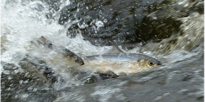
River herring swimming upstream to spawn
Do you ever wonder why there are many water bodies called Herring Pond, Herring River or Herring Brook in southeastern Massachusetts? Not so long ago streams and natural pools came alive in the spring with alewives and blueback herring, collectively known as river herring. They were so plentiful that Native Americans and European colonists caught them in nets and weirs for food and fertilizer for their crops.

As recently as a few decades ago locals caught them in huge amounts to pan-fry, pickle or use as the best bait for striped bass. That’s why they have the nickname “Striper Candy.” Up until a few years ago lots of towns held Herring Festivals to celebrate the spring appearance of the fish as they swam upstream from the ocean to freshwater to spawn.  Gradually, the numbers of herring have diminished due to dams, stream degradation, and overfishing. Now, there is a ban on catching any river herring whatsoever in Massachusetts and seven other states on the Atlantic coast because there are so few left. Fishermen are left without any chance to catch a few for dinner or to put on the fishhook in hope of catching a striper.


Herring hero lifting fish over a dam so they can continue upstream to spawn
Herring hero lifting fish over a dam
But there is hope for the recovery of the river herring. Because dams block most coastal Massachusetts waterways—herring’s travel corridors to spawning grounds-- they cannot breed. But, behold the herring heroes, volunteers who stand for hours at dams lifting net loads of migrating herring up and over dams so they can continue their runs to spawning grounds. Better yet, groups such as the nine member associations of the Watershed Action Alliance (www.watershedaction.org) are removing outdated and dangerous dams or placing fish ladders around them so the herring can more easily circumvent the obstacle.


The Watershed Action Alliance (WAA) also fights for clean water for fish, other wildlife, and people. By keeping streams free of pollution and sedimentation, and maintaining shade trees and riparian corridors, stream water stays cool enough for herring, siltation is reduced and people can swim and recreate without fear of contamination. For instance, one of WAA’s members, the Jones River Watershed Association, removed the Wapping Road Dam on the Jones River in 2011, which allowed herring and eels, among other creatures, to move along the river as they have for thousands of years.


And there’s more. While fishermen forego using even one river herring as striper bait, huge offshore trawlers fishing in Federal waters catch tens of thousands of them. The Atlantic herring is their target, but because the river herring will school with them, they are also netted and legally sold as bycatch. A trawler can catch hundreds of thousands of river herring... in just one tow of the net! Fortunately, WAA members have teamed up with the Herring Alliance to change this, too, so that together we can bring back the herring, a sign of spring and symbol of plenty to Massachusetts residents.

Would you like to see rivers teem with herring, canoe on scenic waterways, and ensure that your children have clean water? Contact your local watershed association to join the effort. Find out more at: www.watershedaction.org
Taking good care of our waterways will help the return of the herring.
 
Photo by Ellen Piaskoski